
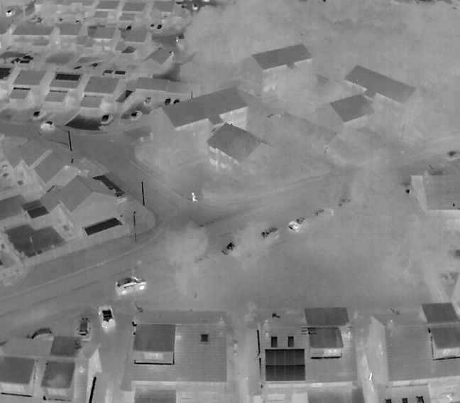
Thermal Inspections
Experience new heights
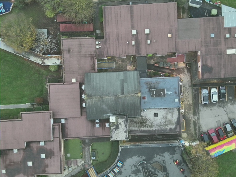
With the advances in UAS technology, thermal imaging by drone has never been as easy or as accurate.
Improve your perspective with Thermal Imaging
Why use thermal imaging?
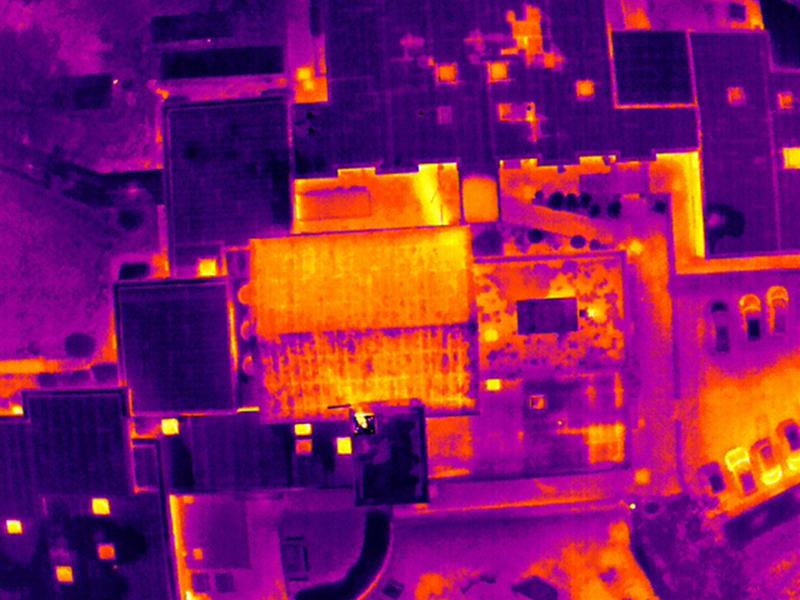
One of the main uses of thermal imaging by drone is to identify key areas of heat loss from properties. The thermal images allow us to see precisely where thermal energy is escaping into the environment. This can be used to help property owners target their attention on improving areas where the heat is being lost. One of the main uses of thermal imaging by drone is to identify key areas of heat loss from properties. The thermal images allow us to see precisely where thermal energy is escaping into the environment. This can be used to help property owners target their attention on improving areas where the heat is being lost.
We work with the latest software to help you work smarter, not harder.
Capture
Capture your images using drones and handheld cameras
Process
Process your images on the cloud with ease.
Interpret
Track site progress by visualizing, monitoring and documenting it.
Integrate
Export your outputs to third-party CAD and BIM software for further steps.
*Completed on client request
What we can do
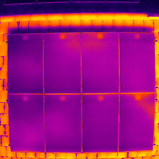
Solar Panel Imaging
Solar panels should produce unform heat as they produce power. When a cell or an entire panel become faulty, this can be easily detected by an unusual thermal signature. A malfunctioning cell will often overheat and create a hot section, or a cool panel among warmer ones suggests that it is not producing power properly. In larger arrays, a deaf string of panels would be obvious due to the thermal output of the panels being different from the functioning strings.
- Fully insured
- Civil Aviation Authority Approved
- Precise
What we can do
Solar Panel Imaging
Solar panels should produce unform heat as they produce power. When a cell or an entire panel become faulty, this can be easily detected by an unusual thermal signature. A malfunctioning cell will often overheat and create a hot section, or a cool panel among warmer ones suggests that it is not producing power properly. In larger arrays, a deaf string of panels would be obvious due to the thermal output of the panels being different from the functioning strings
- Fully insured
- Civil Aviation Authority Approved
- Precise
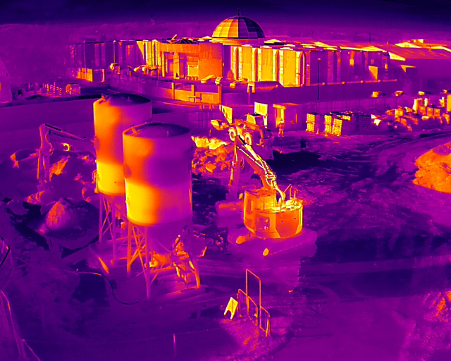
Visualise fill levels
We recently used thermal imaging of cement silos on a building site to visualise the fill levels of the material within. By seeing where the thermal properties of the walls of the silos changed, it could be observed where the material within was absorbing the heat of sun.
Locate objects or faults
Other uses for thermal imaging are for the location of missing persons or pets, leak finding on or gas or water systems, electrical fault finding, or in emergency situations to find locations of fires, or where fires have not been fully extinguished.
- Fast
- Safe
- Effective
Professional results every time
Precise results
Trust Aerial Imaging to get you the results you need
High quality content
Site surveys created using photogrammetry
*Aerial Imaging South East is not a surveying specialist
Safety First
Using my own CSCS cards and PPE allows basic access to most sites following an induction
FAQs
If you have any questions, why not read our FAQs. If we still haven’t answered your question feel free to contact us and we’d be happy to help.
A drone survey is an efficient and effective way to collect data and get an overview of an area.
Drones are becoming increasingly popular for surveying purposes due to their flexibility and ability to access difficult-to-reach places. A drone survey can cover a large area quickly and thoroughly, making it ideal for gathering information about a site before starting a project and during the course of the project.
Drone surveys conducted by Aerial Imaging South East have good relative accuracy.
The whole site is subject to normal GPS variance (+/- a few metres on any axis) but between any two points on the survey, accuracy is good. If higher absolute accuracy is required, the use of Ground Control Points or an RTK system is possible. All prices available on request
The latest technology enables drones to capture high-quality data that can be used to generate reliable results. This makes drone surveys an attractive option for many engineering and construction projects. For more information feel free to contact me.
Drone surveys normally start at £450, this is dependant on your requirements and a full quote can be available on request.
The majority of our work is pre-planned with all preparatory aspects completed ahead of our visit. This means that flight plans and parameters are mapped ahead of time allowing the drone to cover the area autonomously.
Most on site work can be completed in less than an hour. More complex surveys can take longer, but are usually no more than 3 hours. For more information please feel free to contact me.
5 Star Rated
Clients Testimonials
Thanks to our clients